Research
Environmental
Fluid Dynamics

A
study of boundary layer flows in a rotating frame is one of active
research topics in fluid dynamics. In our research, the primary
ingredient of boundary layer flows is the fluid in coastal regions
interfaced with air, land or both, which is closely related to
interdisciplinary subjects in fluid mechanics, coastal oceanography,
electronic engineering, and civil engineering. We pursue to build concrete
frameworks
and to derive potential applications on engineering issues based on
understanding of physics and bio-geo-chemistry, and their interactions.
For
these purposes, we have used observations, numerical simulations, and
theories such as environmental sensing and data analysis, computational
fluid dynamics, and theoretical studies on geophysical fluid dynamics.
Particularly, understanding physics of
coastal waters is vital for tracking of water-borne materials (e.g.,
search & rescue, oil spill, and larvae) and studies of submesoscale
processes, beach erosion, sea level
rise, and fishery science. The tide-driven, wind-driven, and
wave-driven coastal circulations and low-frequency currents as well as internal waves/tides are mainly
examined. (images from an aerial image of red tide and A. Mahadevan, Nature 2014)
see references #4 #5 #7 #8 #10 #14 #16 #19 #20 #22 #26 #36 #37
Environmental BIG DATA
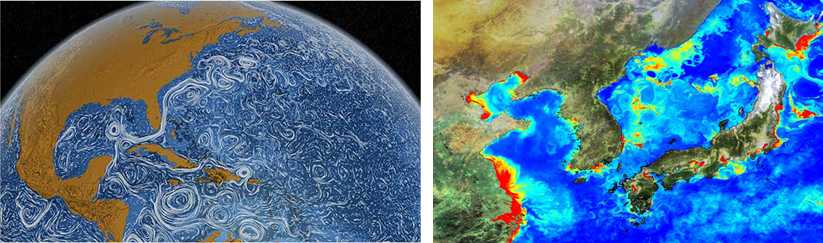
As much as we have been exposed in situations with numerous data, scientific communities have been struggled with the same issues. In our research, the BIG DATA obtained from observations and numerical simulations of various environmental fluids are merged and analyzed based on statistics and dynamics to have better understanding of environmental fluids. Primary datasets are satellite imageries, high-resolution observations and numerical model outputs, reanalysis data at regional and global scales. Data analysis covers several topics; e.g., Fourier analysis in the spectral (frequency and wavenumber) and physical (time and space) domains including signal processing; harmonic analysis; multivariate regression with climate indices; pattern tracking for eddy detection; non-Gaussian process analysis; self-similar time series analysis; filter design; objective mapping, and etc. (images from the perpetual ocean from NASA satellite products and GOCI Chlorophyll)
see references #10 #14 #17 #20 #22 #25 #28 #29
Submesoscale Processes
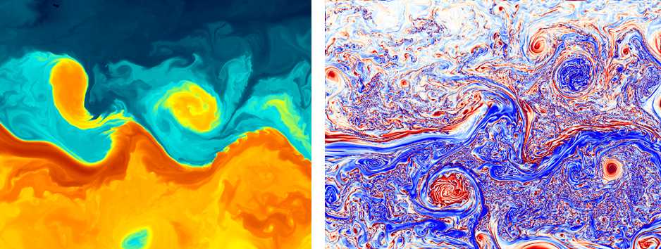
Submesoscale
oceanic features, which are frequently observed as filaments, fronts,
and eddies, are characterized by both O(1) Rossby number and a
horizontal scale smaller than the first baroclinic Rossby deformation
radius. Submesoscale processes are important because they contribute to
the vertical transport of oceanic tracers, mass, and buoyancy and
rectify the mixed-layer structure and upper-ocean stratification.
As observational studies requires to sample the waters at the O(1) km
spatial scale and less than an hour temporal scale, we have used the
high-frequency radars for surface current observations and intermittent
in-situ CTD samplings for the vertical structure. As one of on-going
research topics, the energy cascade of geophysical turbulent fluids
has been investigated. (images from
J. Gula @
UCLA)
see references #5 #6 #7 #8 #27 #30 #31 #32 #34 #36 #37
Environmental Sensing

"The chief source of ideas in oceanography comes, I think, from new observations... On the whole, when it comes to the phenomenology of the ocean, there are more discoveries than predictions. Most theories are about observations that have already been made." - Henry Stommel
Environmental sensing includes 1) development and fabrication of sensors, 2) data quality assurance and quality control (QAQC), and 3) sampling design, which requires a diligent and smart team having interdisciplinary
backgrounds such as fluid mechanics, electronic engineering,
oceanography, and etc. Primary topics are listed: signal
processing; time-frequency domain analysis; sensor fabrications;
sampling design; surface current
observations using high-frequency radars; sea surface heights,
temperature, and chlorophyll using
satellite remote sensing (e.g., AVISO, coastal altimetry, and GOCI missions); acoustic
Doppler current profilers (ADCPs); integrated coastal ocean observing
programs. [images were taken during field works off Republic of Palau, California (USA), and Majorca (Spain)]
see references #1 #2 #14 #17 #24 #35
Machine Learning and Inverse Methods
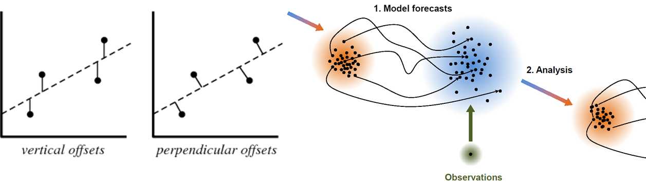
A
typical problem in science and engineering,
Ax = b,
where A and b denote the known model coefficients and given
observations, respectively, and x is unknown model parameters,
is tackled in various ways: e.g.,
least-squares fit, (multi-variate) regression,
empirical Greens' function analysis, data assimilation, Kalman filter,
optimal interpolation,
Fourier analysis, gap filling for missing observations, statistical
parameterizations,
and etc. Statistical and dynamical data analyses allow us to understand
the big data obtained from the nature in a dynamical framework.
see references #1 #2 #3 #4 #7 #8 #17 #18 #25 #33
Science and Engineering in Extreme Environments
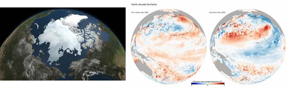
As one of extreme environments, the arctic area is our study domain regarding on the sea-ice variability and dynamics, and infrastructure building on met-ocean data for offshore engineering. This can be extended into the studies on climate change at regional and global scales based on observations, numerical model outputs, and reanalysis data as a part of BIG DATA analysis (e.g., signal processing). The typhoon's (Hurricane and tropical cyclones) generation, migrations, and demise can be analyzed in a similar context. The storm surge and the drag variability under high speed winds are one of on-going research topics (images from NASA and N. Mantua for PDO).